Sunday, May 31, 2015

Comox to Tofino - Day 18: Grant Bay

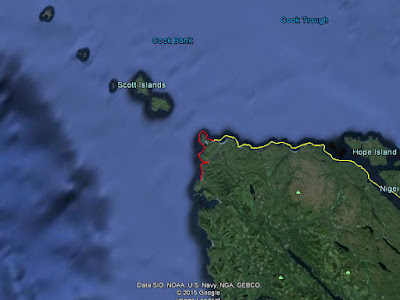
Raft Cove to Grant Bay: 13.2 nautical miles

It is hot. The beach here is protected from the wind by thousand foot high mountains, the sun is out and I am hiding in my tent to try and stay cool but it isn't working.

This beach is accessable by road and there is abundant evidence of human activity. There is what I believe to be the debris of a crazy, teen party; lots of beer and pop cans, a cheaply made, abandoned tent with pillows decaying inside and a fry pan in the sand. There is a shelter frame made from driftwood that is badly burnt on one side, a fire must have got out of hand. A day-use shelter made of driftwood and blue tarps is surrounded by garbage. Numerous fire pits line the beach with half-burnt logs, sand piled on top and littered with discarded cans and food containers.

I find it hard to believe how people are able to treat such an amazing place. I am used to beach flotsam but this is obviously brought by the people who visit and then just discard their waste and it is only May on a beach that would be cleaned by winter storms so this is just what they have done so far.

From what I have come to think of as the 'teen-party massacre', I was able to salvage some provisions:
    • roll of waterproof, medical tape
    • can of Chef Boyardee Lasagna
    • 2 cans of Hienz Beans with Bacon
    • can of Fresca (really looking forward to this once it cools)
There are also 3 cans of Diet Pepsi but I didn't take them. I am using the fly of the abandoned tent to shelter my boat and food from the sun. Later, down the beach I acquired four grape tomoatos from an abandoned lunch.

Today's paddle from Raft Cove was excellent; the swell is low, there was light wind was at my back and the shoreline was interesting with Sea Stacks and other features. I had lunch on a nice beach that seemed to be seldom visited. I looked for glass balls but found none. 


Saturday, May 30, 2015

Comox to Tofino - Day 17: Rest Day

I had a rest day today and it felt amazing. I can hardly believe that I went over two weeks without a break but with the weather cooperating and being determined to have this expedition be a success, I was always pushing myself to keep going. I had thought when I did stop, it would be a awful, rainy day, but it was sunny and I couldn't have been more thankful.

I slept in, drank coffee and read my book. I felt I should be taking advantage of the sunny day more and exploring, the area up river looked interesting, but really what was best for me was just to do nothing.

I ate some of the canned food that was in the cabin and will probably take more with me; soups, beans and a chili sauce. I hope that is the right thing to do. I have a hard time imagining an emergency situation it would be needed for and I think it is there because the people who brought it didn't want to take it back with them. All of the best before dates are fine.

To balance out the karma books I swept diligently, cleaned all the ash (and garbage) out of the stove and cleaned up all the plastic trash in the yard with a big fire. Also, I thoroughly cleaned my body with soap in the river; fully lathering and rinsing twice. The less salty water felt great. Afterwards, I was actually nauseated from the smell of the soap. I wondered if this is how dog's feel when they get a bath. I considered taking the soap with me but decided against, it felt like taking to much from the cabin.


Friday, May 29, 2015

Comox to Tofino - Day 16: Raft Cove

Lowrie Bay to Raft Cove: 11.0 nautical miles

I departed Lowrie Bay at 9:30 am. I wanted an earlier start in case the wind rose later in the day but it was tough to rouse myself, it being my first time with a roof over my head in over two weeks. The cabin shelter here is rough but rodent free and functional. It was just as well because I had a light wind at my back for the entire paddle, ideal conditions.

I paddled in to check out Sea Otter Cove and there was a Sea Otter right there at the entrance! The Helen Islands also at the cove's entrance looked like they would be a nice place to camp.

I passed by San Josef Bay but did not go in because it was to big to explore. Hopefully, I can arrange a trip here with some friends at a later date because it would be great area to investigate. Next, Cape Palmerston wasn't difficult to paddle around because the swell is low today. I saw a very large pile of logs on one beach, as if made by a Lodge of Giant Beavers.

Raft Cove was a busy place; five to ten surfers in the water and another dozen people milling about on shore with tents along the beach. With so many people around, I didn't think I would be able to stay at the cabin. I brought my kayak onto the beach a ways away on the south side of the Macjack River and went to investigate. There was no one there. I doubled back, hauled my boat back into the water, paddled through the turbulent water where the river reached the ocean and moved myself in.

I don't drink coffee often but there was some left in the cabin and I brewed myself up a cup, cooking it up Slovenjian style.


Thursday, May 28, 2015

Comox to Tofino - Day 15: Lowrie Bay

Experiment Bight to Lowrie Bay: 11.4 nautical miles

I awoke to a chilly morning. I was able to start later than what I have been and I enjoyed the lie in. The ocen didn't look as benign as I was hoping but it wasn't bad either. I packed up and was on the water at 9:35 am, only ten minutes before slack tide at Cape Scott.

Today, I was wearing my helmet because of the launch through the surf. Yesterday, I had watched and seen where the tide rip flowed out and away from the beach and I launched there. I plowed through a few small waves and then a bigger one and I was out to sea, riding the tide rip like a conveyor belt.

At Cape Scott, it didn't look bad but I knew I was unable to see all of it. I stayed well off shore but when I got there it was huge! Four meter swell going this way and that like a giant sloshing around water in a bucket. I forged ahead and before too long I had made it around. It wasn't calm seas on the far side but it was certainly less intense.

I tried to get a picture of the Cape Scott Lighthouse but it was obscured by the trees. I had a good view of Guise and Hanson Bays. The latter was very nice looking in the sunshine that was just beginning to break through.

I attempted to paddle in and see Hanson Lagoon but with the falling tide there was a current flowing out and also a strong wind blowing against me. I stopped at the entrance and took a few pictures, then it was on to Lowrie Bay. I passed a Humpback Whale on my way there. Lowrie Bay is awesome in the sun and I enjoyed relaxing there all afternoon.

Observation: I waded in the water and saw two schools of fish; herring and rockfish. The rockfish stayed safely in the seaweed. I tried to herd the herring by walking around them but they evaded me.


Wednesday, May 27, 2015

Comox to Tofino - Day 14: Experiment Bight


Cape Sutil to Experiment Bight: 15.8 nautical miles
...and then the sun came out, ahh! At about 5:00 pm, it cleared up and my cold, grey world turned into a tropical paradise. As I watch the medium-sized waves roll in on the beach, I can see Bull Kelp waving in the waves clean face.

Observation: While feasting on Pacific Blue Mussels, I noticed I had inadvertantly also steamed Shore Crabs that were inside the mussel's shell. The crabs had a very delicate shell and I think they were in the process of regrowing it after moulting. I wonder if Shore Crabs intentionally hide inside mussels when they are in this vulnerable state.

I woke to a calm, cool morning. I noticed a Raft of Sea Otters in the kelp off the beach. On this day's paddle, I would see them consistently everywhere in the near shore environment. It gives me a good feeling knowing they are back after a long, two hundred year absence.

The water was turbulent. This a a different beast to navigate. Christiansen Point was particularely big. Stellar Sea Lions were guarding the rocky shores where it was the worst, adding a layer of intensity to the day. They have an unnerving vocalization. One pride was about fifty individuals, all swimming in a mass blob. A loner swam behind me for a couple of miles. I yelled at him, "Go play with your own friends!"

I stopped at Nissen Bight for lunch and it was cold, wet and uninviting. No one was there. I saw a Grey Whale on the way in. I carried on by Nels Bight and saw campfires from a distance. I arrived off shore at Experiment Bight and sussed out where the best camping might be. There was decent swell here and I was happy to successfully land through the 1-1.5m breaking waves. It was cold, so I madea big fire but then the sun came out. Wearing just shorts felt so nice after a few days wearing many layers of clothes. I made a clothes line and gave all my clothes and gear good airing out.

Later, I noticed the moon. I started the trip during the New Moon phase and this is the first time I've seen it on the trip. It is already a day past the First Quarter phase. The sunset tonight was gorgeous.


Tuesday, May 26, 2015

Comox to Tofino - Day 13: Cape Sutil, Vancouver Island

Nolan Point, Balaklava Island to Cape Sutil: 18.6 nautical Miles

 It was a cold morning but the fire took care of that. I was up at 5:20 am (a 20 minute over-sleep) and on the water at 8:00 am. I paddled up the shore of Nigei Island and found it to be a very interesting shoreline with cliffs, caves and sea stacks. Also, there were a number of streams and small waterfalls. I topped up my supply of water. In the Kelp near Loquillilla Cove, I saw two more Sea Otters.

I crossed Goletas Channel aiming towards the far Northern end. The ebb tide should have been carrying me along, however the wind and swell were against me and it seemed I couldn't be making any progress. Then in no time, I passed Shushartie Bay the start of the North Coast Trail. I was tired and had been paddling for 3 & 1/2 hours but decided to carry on to Jepther Point for lunch.

Jepther Point is an attractive spot not accessable to hikers on the North Coast Trail and is a place I have wanted to see since I hiked it with friends a few years ago. While there, a pair of Common Loons swam around like a couple strolling a city park, going first this way then turning and coming back.

I paddled on, scanning the shore and seeing what I could remember from when I had hiked along it. I rounded Cape Sutil and made my camp in the same spot where I had camped with my friends on the third night of the trip. Having the kayak certainly doesn't make it seem as far.


Monday, May 25, 2015

Comox to Tofino - Day 12: Nolan Point, Balaklava Island

Peel Island, Beaver Harbour to Nolan Point, Balaklava Island: 12.9 nautical miles

It was cold and foggy all day and there was a bit of drizzle. I paddled through God's Pocket, a lovely archipelago with too many fish farms.

The camping spot was a delightful surprise. It is big; fifty people could camp here at once, and adjacent to an Indian Reserve. I wonder if they have big clan gatherings here and imagine old granny sitting on the bench where I am, staying warm by the fire.

I made the fire very big and then went for a swim. I am less timid about getting in now. I know I am doing it, so I just get it done.

I harvested Mussels and ate one. My stomach didn't like the last batch I gathered a few days ago and I'll see how these ones are. If I'm feeling fine tomorrow then I'll have a feast.


Sunday, May 24, 2015

Comox to Tofino - Day 11: Peel Island, Beaver Harbour

Pulteney Point, Malcolm Island to Peel Island, Beaver Harbour: 11.3 nautical miles

It was a great morning! Foggy and a little chilly, it was tough getting out of the tent but once the fire was going and I could enjoy the scene, so good. The 7:00 am start felt like a sleep in!

The shoreline of Vancouver Island kept drifting in and out of the fog. Once I was on the water, visibility was good. A Rhinoceraus Auklet came up right beside me and sat there in the glow of the sunshine for at least a minute, if only I had the camera handy. (I like to put it away from time to time so I am not a slave to it.) Next, a Humpback Whale passed through, almost intersecting my path and surfacing half-a-dozen times.

When I reached the Vancouver Island shore, I found an attractive beach. The shoreline provided no protection from the wind however and thick fields of Giant Kelp kept me well out. Paddling along, I saw a Sea Otter! The first I have seen on the east side of Vancouver Island. I love seeing these guys expanding into new territory.

The wind picked up and I had a fight on my hands working my way past the Port Hardy Airport and into Beaver Harbour. I arrived at camp by early afternoon and then had lots of relaxing time. I made my call home to Mom and texted Kip.

I couldn't get myself into the water for a swim and am now regretting it. 


Saturday, May 23, 2015

Comox to Tofino - Day 10: Pulteney Point, Malcolm Island

Double Bay, Hanson Island to Pulteney Point, Malcolm Island: 16.4 nautical miles

I traveled a lot of miles very quickly today, through a combination of having found a good paddling rhythm, no wind and a favorable current. I went around the opposite side of Malcolm Island than I had been planning. From my current on-water perspective, it just made obvious sense to go that way. I am happy that this trip is honing my navigational savvy.

Paddling past Cormorant Island (the location of the Alert Bay community,) Sointula and Port McNeill I felt like I was back in civilization.

Pulteney Point which I could see on the horizon most of the day and around which was my destination, surprised me by having a lighthouse. I even fooled myself by thinking the lighthouse was a navigational marker and thus thought I was much closer to it than I was.

My camp here is a little different (I guess they all are, really.) It is not an established camping spot and I have my tent hidden behind a very large log because this side of the island is exposed to the wind. There is no development around me and I paddled far enough down the shoreline from the lighthouse that it is out of view. The beach is comprised mostly of boulders and has just the hint of swell, a foreshadowing of the west coast still to come. Behind the beach, the forest rises up a steep hillside.

Tomorrow, I head up to Beaver Cove on Vancouver Island. My first return to that shoreline since paddling away at Little River. However, I won't be stepping ashore on the main island until a bit later in the trip.


Friday, May 22, 2015

Comox to Tofino - Day 9: Double Bay, Hanson Island

Islet NW of Klaoitsis Island to Double Bay, Hanson Island: 12.6 nautical miles
 
It feels comforting to be back in familiar territory again. About half-way through today's paddle I started to recognize where I was from having previously done some guiding work here. Tomorrow, I return to the unknown and it is satisfying to feel I am moving through an area so quickly.

This morning was intense dew and fog which at times turned into drizzle. Trying to keep my stuff dry was laborious. I was on the water at 9:30 am, a half-hour ahead of schedule. I guess I didn't want to hang around there.

The inter-tidal scenery was first rate in the Klaoitsis Island Group and also through Beware Passage; very big Barnacles. It was not difficult to navigate Beware Passage, it has lots of rocks and islets so it is probably only a problem in a fast moving boat. I found water on Harbledown Island. It was just a trickle and I am amazed again that these rainforest islands don't have much obvious water.

I saw a bunch of Whelks making a carpet of eggs. I have seen these egg clusters before but have never seen the Whelks in the process of making them.

I crossed Blackfish Sound just after slack, there was no wind and it was an easy crossing. I got to camp at about 2:00 pm and spent the rest of the day relaxing and drying out. Luckily there was a light breeze and my clothes dried even without the direct sun.

I went for a swim to stay clean and it was the most difficult immersion yet; cold and with no sun to warm me up after. I feel so much better afterwards though that it is worth it.


Thursday, May 21, 2015

Comox to Tofino - Day 8: Islet NW of Klaoitsis Island

Broken Islands to Islet NW of Klaoitsis Island: 22.3 nautical miles

The camp in the Broken Islands was obviously on the route for boaters and water taxis and there was a lot of traffic. I was down at the water when a boat went by particularly close, so I gave him a wave. He stopped, turned his boat around and asked if I was 'ok.' I said, "Yeah, thanks man." He had a dog in his boat.

I had a lot of miles to do today, which was hard after yesterdays fight against the wind but I got help from the current and only had to push hard in one short, exposed section. Johnstone Strait really funnels the wind, especially during sunny weather, and there is a lot of fog as well.

This morning, while headed up Hannah Channel, I got a look up the passage which doesn't quite separate East and West Cracroft Islands. There were a lot of houses and lots for sale. I think it is far enough away that it has escaped the real estate boom. Between Call Inlet and Chatham Channel, at Hadley Bay was an abandoned looking Hamlet with a dilapidated fish packing plant.

I got a ride on the current in Chatham Channel. This was not what I was expecting; I must have been out-of-it from all the recent hard labour while working out the tides. I thought I was going through at slack so the help was a nice surprise. There are no rapids in this channel so nothing to worry about.

The Minstrel Island cluster of buildings were all painted an ugly, aquamarine colour.

I got a bit turned around trying to find Clio Channel, not having a chart for the area and ended up paddling deep into the bay that separates East and West Cracroft Island on the North Side. Then, when trying to find a camping spot, the site that was described in John Kimantas's book was not useable, so I just had to make do at a random spot. It wasn't to troublesome, though I felt lucky that the weather was so nice. This type of event makes it feel more like an adventure.

I will need to paddle less miles tomorrow so hopefully I will get some down time, though I do need to find some water and not get lost in 'Beware Passage'.


Wednesday, May 20, 2015

Comox to Tofino - Day 7: Broken Islands

Poyntz Island to Broken Islands: 19.0 nautical miles

I had a long slog today paddling against the wind to get up Johnstone Strait. It is a beautiful area; snow-capped peaks, rocky shorelines, sunshine and a lot of wind. This section of Johnstone Strait is the closest the mainland and Vancouver Island get to one another, about 1.5 nautical miles.

Blenkinsop Bay was uninhabited and looked attractive. Just before there, I stopped on a beach for a break and followed an estuary a ways looking for water. It was brackish though and I gave up. There are more water sources in this area.

I ate Sea Asparagus with dinner last night. After lunch today, I found some Salmon Berries for dessert and this evening's meal was mainly Oysters. I am almost out of those and will need to look for more shellfish soon.

The Broken Islands are nice but the campsite is back in the woods. At first, I was disappointed but eventually I found I liked it. It was almost like being indoors and maybe a change is good. I saw Gumboot Chitons at my lunch stop and also here at camp; this area must be a good place for them.


Tuesday, May 19, 2015

Comox to Tofino - Day 6: Poyntz Island

Cordero Island to Poyntz Island: 15.7 nautical miles

I had a very early start today, 3:30 am. The currents are strong here and fighting them is a waste of time, so I got out early and caught a ride while they were going my way on the ebb.

I was on the water just after 6:00 am. I like to enjoy the morning, having a good oatmeal breakfast cooked over a fire so it takes me a while. I paddled through Green Point Rapids about an hour after slack and they were starting to pick up, white water appearing at some spots. All the way along Chancellor Channel to the entrance of Loughborough Inlet the water was turbulent and I travelled a lot of miles quickly.

So far on the trip the weather has been dominated by a strong high pressure system lying off the British Columbia coast, similar to the usual summer pattern. This usually creates fog near the shoreline on the North and West sides of Vancouver Island and this morning it was foggy and cold.

It felt like a long time but really it wasn't and I was turning up into Wellbore Channel and I was glad to find the current strong and helpful all through there. In fact, I mostly just sat in the boat and let it carry me. Whirlpool Rapids lived up to its name with many whirlpools lined up in a row. I was easily able to paddle along beside them without being sucked in.

Poyntz Island is a cool place; it has two larger, hilly ends connected by a low lying neck that has beaches on either side. There are a couple of tent areas pruned out of the Salal. The sun came out on cue at lunch and I spent the afternoon snoozing in my tent.


Monday, May 18, 2015

Comox to Tofino - Day 5: Cordero Island

Walkem Islands to Cordero Island: 6.1 nautical miles

I only needed to paddle a couple of hours this morning. I came up Mayne Passage and through Blind Channel at slack but then was confronted by the Green Point Rapids running against my direction of travel. The tide book said they would not change direction until late in the afternoon, so I quit and enjoyed an afternoon off.

This island is small with minimal evidence of past camping, you could miss it if not looking for it. When I was setting up my tent I found a camping knife (of the utensil variety) and I knew people have been here.

This is a beautiful spot and the nature appears unspoiled. Blind Channel Resort is close by but not visible. I went for a swim and it was very chilly but it felt great to lay out on the hot rocks afterwards.


Sunday, May 17, 2015

Comox to Tofino - Day 4: Walkem Islands

Octopus Islands to Walkem Islands: 16.9 nautical miles

I was brave and paddled through the Upper Okisollo Rapids 40 minutes before slack. There are many fish farms around the North end of Quadra Island and abundant logging activity as well. This area has large populations of Urchins, Chitons and Limpits and less of the Barnacles I am more familiar with. I think it is the result of the stronger currents here.

At lunch, I found a Salmon Berry patch and had a feast while being mindful for any Bears in the area. I paddled against the current all along Johnstone Strait, staying close to the shoreline and seeking out back eddies.

Late in the afternoon, I took a break on East Thurlow Island and made myself a snack by steaming some Oysters in their shells beside a small fire. After getting back on the water thunder clouds appeared and I heard lightening in the distance, so I made camp in the Walkem Islands. I have only a short way to go tomorrow because the currents aren't working in my favor and I will be blocked by the Green Point Rapids.

It is beautiful here despite all the industrial activity and easy to imagine how awe-inspiring it would be in a pristine state. The currents are giving it an adversarial feel for me.


Saturday, May 16, 2015

Comox to Tofino - Day 3: Octopus Islands

Shark Spit, Marina Island to Octopus Islands: 18.3 nautical miles

Lightening Storm! It started when I was making dinner. I got my tarp up and it turned out to be just some light rain. The first, not totally benign weather of the trip. There are mosquitoes here to – grr.

I had a nice day of paddling. I feel like I am making good time so far, though I've barely begun. I am tired but feeling positive. I saw Harbour Porpoises this morning.

Today brought back many early paddling memories. Ten years ago, I did the Coastal Adventure Tourism program at North Island College and we did our first overnight trip in Surge Narrows which I paddled through today. The following summer I got my first assistant guiding job working in this area for the company Coastal Spirits. Even earlier, probably around the year 2000, Mark Willms and I did an overnight kayaking trip here, a first for both of us. I believe I am camped on the same island as on that occasion.

Tomorrow, I am moving into new territory. The adventure builds.

Friday, May 15, 2015

Comox to Tofino - Day 2: Shark Spit, Marina Island

Savary Island to Shark Spit, Marina Island: 14.4 nautical miles

I was feeling a bit tired when I reached Shark Spit so I decided to camp here. It was another beautiful day. I harvested some Oysters from Hernando Island as I paddled by.

There is another couple camping here as well. I am trying to not find them annoying. They camped near to me even though there is a lot of room. I can hear the woman's cackle laugh.

I wonder if later in the trip, when I am on some isolated beach by myself, if I will miss the feeling of safety other people provide. I think I will and so I try not to be annoyed now and thus forgo being a hypocrite.


Thursday, May 14, 2015

Comox to Tofino - Day 1: Savary Island

Little River to Savary Island: 12.7 nautical miles
It was an easy crossing from Little River. 13 nautical miles completed in 3 hours and 44 minutes. I think there must have been a current helping me along.

Savary Island is paradise. I went for a swim right after getting here and the water was warm. I haven't seen any other people. There is lots of broom; a noxious, invasive plant. The weather is great and I hope it stays like this as long as possible!

I had planned to paddle to Shark Spit on Marina Island tomorrow but I might try to go further, maybe the 'Orchard' on Read Island.

I have many reasons for doing this trip but I don't think any of them matter. I need to be open to whatever this experience can teach me, success or failure is of no consequence. I want to be happier in life. While I am out here, I am.